Posted by: Rick
On Monday, August 10th, Lynne and I left the dogs at the cabin and drove up the Laramie River Valley to the Chambers Lake area, where Co Rd 103 (the Laramie River Valley Road) meets US Highway 14. There is a small lake north of Chambers Lake called Lost Lake, and it has long been a favorite place to fish for rainbow trout. We wanted a couple of trout for dinner, and after a couple of hours had what we needed. Even though these are stocked trout, they are not that easy to catch!
Below is a photo of the area. The lake is surrounded by forest and covered with lily pads.
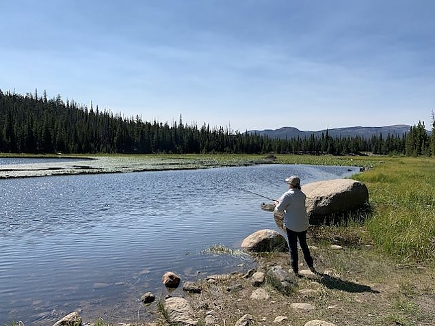
Three days later a wildfire consumed this area. I'm sure it won't look like this again in our lifetimes. Once it is safe, we'll try to recreate this photo for a before-and-after comparison.
Called the Cameron Peak Fire, it is believed to have been started by human activity. Probably a camper ignoring the fire restrictions that are in place. The whole area is suffering from a 20-year drought as well as significant dead fuel from beetle kill. I'd estimate somewhere around half, maybe more, of the trees are dead. Many have fallen, others are still standing. And, even the live trees are dry and brittle. It is an area ripe for a wild fire, and it has finally happened.
The Cameron Peak Fire is the 4th major fire burning in Colorado. All the fires are competing for resources.
Here is a satellite thermal image of the fire front. The red dots represent hot spots in the past 12 hours, orange are in the period of 1 day, and the yellow is 2 days or more. Updated versions of this can be found at: https://maps.nwcg.gov/sa/#/%3F/%3F/40.6085/-105.893/10. Not also the small fire on the far east side. This is just outside of Fort Collins and started yesterday.
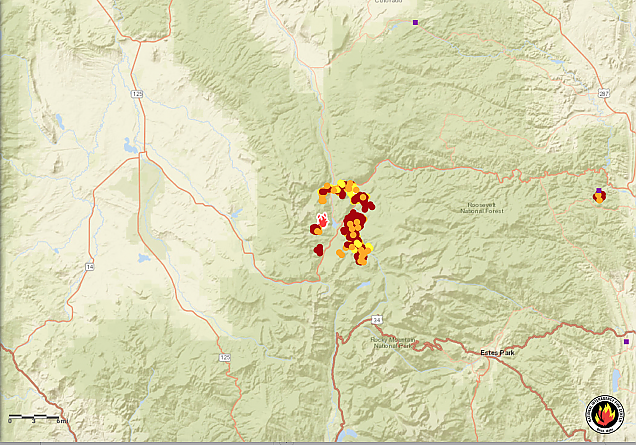
The fire fighting team is taking a conservative approach to fighting this fire, while promising a full suppression strategy. And, I can't argue with their approach. So far, the fire has not damaged any buildings. Even the local campground was saved, although the forest around it is burned. The terrain is very rough with steep mountains, rocky scree, and of course a tangle of downed trees. It is impossible to fight the fire at its perimeter, so they are building defensive lines all around the fire. They are identifying roads, trails, avalanche chutes, rocky cliffs, and changes in terrain and vegetation that can be used or "improved" to create lines where they can fight the fire on their own terms. Once at timberline, for example, the fire will run out of fuel. Often trails and roads can be widened, removing trees to create a wide defensible area. Other natural land barriers can be connected together with new defensive lines. As of today, they have almost completed a huge circle of defensible space around the fire. Once in place, they can more safely purposely back-burn the forest to remove fuels in a controlled way.
The most northerly defensive line is about 1/4 mile from the cabin (Larimer County Road 80C).
However, to be fair, once the outermost lines are in place, they have started moving in toward the fire looking for additional defensive lines and are working on Deadman Road now, providing more buffer.
As of today, I am not too worried for the cabin from this fire (but, given the conditions, there could be others.) The winds have been out of the North or Northwest for the past week and that has blown the fire across Highway 14 toward Rocky Mountain National Park and west toward Pingree Park and Crown Point. The fire is also a threat to the vacation/tourist town of Red Feather Lakes, especially if the winds shift to their normal westerly direction (coming from the west).
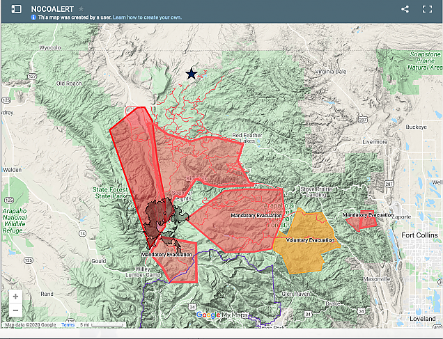
There are massive manditory evacuation areas along with many road closures. The next photo shows those. The star at the top is the approximate location of the cabin. The gray area is the current footprint of the fire. The red manditory evacuation area furthest east is the new fire near Fort Collins. Updated versions of this can be found at: https://nocoalert.org
Here is another neat source of fire information. It is a collection of daily images taken by NASA, so that you can see the progression of the fire day by day by clicking on the dates at the bottom of the page.
We got a bit of a scare yesterday when we learned of a new fire a few miles to the east of the cabin. But, it was quickly identified and a few helicopter drops of huge buckets of water from Eaton Reservoir and it was doused.
The latest information about the fire as well as updates to evacuation orders and road closures can be found here: https://inciweb.nwcg.gov/incident/article/6964/53611/
We have been to the cabin a couple of times since the fire started. We have to go through Laramie, WY and drop down into Colorado since the road we ususally take, Co Rd 80C, is closed (although I've heard some people have been able to access the area via that road). There are a lot of road closures in the forest for several reasons, One, they don't want anyone to get caught in the fire if it flares up and moves quickly. But, perhaps more importantly to minize traffic allowing the fire fighters and heavy equipment unimpeded access.
Because the prevailing wind direction is north to south, we had a few good, clear days. But, recently the winds have died down (a very good thing), allowing smoke to settle over the whole area. To make things worse, there is also a fire burning near Saratoga, WY and we started getting smoke from that. We cut short our most recent trip to the cabin because the smoke was so bad. However, it is no better here in Windsor. At least here we have the air conditioning and fan to filter the smoke some and keep us cool.
I feel terrible for those that are more threatened than us. I feel terrible for the wildlife trying to escape the fire. I really appreciate the fire fighters, forest service and local sheriff's office for the fantastic work they are doing, especially the frequent and informational public briefings via FaceBook. (Just search for Cameron Peak Fire.)
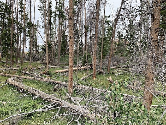
We have done a lot of wild fire mitigation at the cabin. About 10 years ago, just after the beetle kill was at it worst, we had about 200 trees removed due west of the cabin. This created an open meadow and a defensible space on the side from which a fire is most likely to come. It also created a nice place for deer, elk and moose to occasionally congregate. You can see a view of that meadow in a "pinned" article at the top of this website homepage. Just click on "Home" above.
And, recently we had even more downed, dead trees "removed" from the north side of the meadow. Here is a photo of what it looked like prior to this work:
And, here is a photo (although taken from a different spot) of what it looks like now:
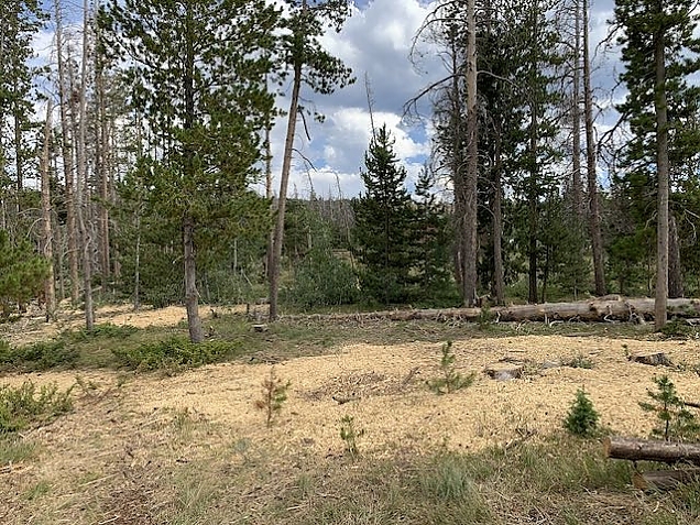
The crew we hired dealt with fallen, dead trees--mostly by chipping them in a huge chipper, but also by cutting the larger ones into logs that are neatlly stacked on the land and available for firewood. You can see the wood chips in the photo above. We will do this kind of work each summer, up to what we can afford, to further minimize the chance of a wild fire starting (from lightning) or moving through the area aggressively.
So, we are stuck at home. Sitting in the air conditioned house. Binging on TV, reading and playing games. It is too miserable to be outside both because of the heat and the smoke.
2020 is sure stacking up to be a sucky year.
Posted by Rick on 08/23/2020 at 11:23 AM
Tags:
cabin,
photos,
weather,
nature
Filed under:
Everyday Life •
Summer
Permalink
Posted by: Rick
I recently volunteered, through Trout Unlimited, to help with some research being done by a CSU Masters Student and funded by Colorado Parks and Wildlife. The task was to electrofish for brook trout in two streams close to the cabin--Sheep Creek and George Creek, collect data on their size, and then take a small clipping from a fin to use for genetic analysis. There were four of us on this expedition including Dr. Kurt Fausch a retired professor at CSU from whom I learned a lot about fishes, fisheries, native versus non-native species, reclamation, and more. He is the author of a book For the Love of Rivers, which you can learn more about at the website: fortheloveofrivers.com. He is passionate about what streams and rivers bring to the human experience beyond the obvious--water. The others were masters student, Audrey as well as an undergraduate, Matt.
Brook trout are not native to Colorado, yet they are the most populous species in our streams. They were likely imported from the east in the late 19th century. Because of their spawning cycle (fall, not spring) and aggressive feeding, they have replaced native species such as a variety of cutthroat trout in most Colorado waters. There are a variety of research and reclamation projects going on to bring the cutthroat back. Around here, the native species is the greenback cutthroat.
I can't say I fully understand Audrey's research. But, I know she is heavily involved in a project to reintroduce native cutthroat trout into some headwaters in the Long Draw area. In order to understand how the introduced trout will move throughout the area, breed and migrate, she is doing genetic diversity studies on the existing brook trout. To have something to compare with, she needs genetic information from brook trout in other areas and George Creek and Sheep Creek were two of the chosen sites.
We drove into George Creek by taking S County Road 169 where after a few miles, we took a 4WD road to ACME Creek road. It was a pretty rough road and I was proud of our Ford Expedition's performance in 4WD over the rocks and washout. We even drove through the burned out area from a wildfire a few weeks ago. We did not take the obvious ACME Creek Road because of a need to do a river crossing at Sheep Creek which has a lot of water right now. We eventually arrived at George Creek and prepared for the electrofishing.
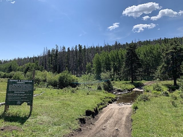
The sign here is an old sign from a previous attempt to introduce greenback cutthroat. The road continues on to Cornelius Creek.
Over the past several years, brook trout have been removed from George Creek in preparation for stocking with the native and threatened greenback cutthroat. This attempt has been unsuccessful based on our electrofishing experience. We managed to catch well over 100 brook trout along a few hundred meter span of the river. Don't get too excited if you are a fisherperson. None of them were "keepers". In fact, the majority were less than a year old (about 50 mm in lengh), the rest were one year old and perhaps a few that were 2 years old or older. The fish hatch in spring and then grow in the summer, and they will grow at a roughly uniform rate. As a cold-blooded animal, they halt growth in the winter. So, we could tell age from the length of the fish. The biggest one was perhaps 6" long, probably 3 years old. In fact, I learned that there are bones in a fish that get a new layer each day, so sectioning those bones and counting the "rings" can tell the age in days! We did not do that. Instead, Matt carefully measured the length of each fish while I recorded the length on paper. He also took a genetic sample from any fish one year old or older and Audrey carefully collected and tagged each sample in a separate envelope.
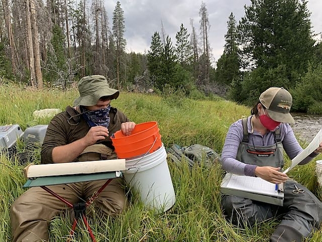
Matt and Audrey processing the fish we caught.
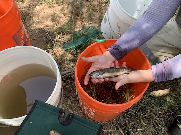
One of the bigger trout from George Creek.
Electrofishing sounds a bit scary. (And, it was when there was some lightning later in the day.) But, it is largely harmless to the fish. You wear a backpack that has a battery in it along with controls to set up the electic shock parameters (wave shape, frequency and voltage). There is an anode probe and a cathode "tail" that come from the backpack. You walk along the stream with the tail dragging in the water, and press a trigger on the anode probe to create an electrical path through the water. This shocks any nearby fish for a few seconds. The goal is to catch the stunned fish in a net and move it to a bucket of water quickly. The fish recover within a few seconds. After catching a bucket of fish, we'd stop for a while to process them.
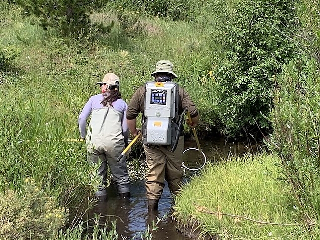
George Creek is quite small so it was mostly a 2-person project with someone to carry the bucket (me).
We wore waders, which insulated us from the shock. But, I'm told it can be quite an experience to accidently touch or fall into the water while using the electrofishing machine. So, we had a protocol to yell out "OFF" if I fell while trailing behind with the bucket.
I had a net too. And, I snagged a few of the fish. But, the more experienced people did the bulk of the "catching" work.
After we were done at George Creek we had lunch and then moved on to Sheep Creek. And, we decided to take the ACME Creek road back to County Road 80C and brave the water crossing. The road was actually in pretty good shape since they likely graded it and cut trees on the way to help with gaining access during the fire. The water in Sheep Creek was pretty fast and pretty deep since they are letting a lot of water out of Eaton Reservoir (for the city of Greeley). But, the Expedition plowed right through without any problems.
At Sheep Creek, we used two electrofishing machines, Kurt took one and Matt the other. They each had nets and Audrey was netting also. I, again, was the bucket boy. I did not want to wade in the fast water and risk dumping the bucket of caught fish. That would not have been good at all. So, I walked along the bank. When they'd net a fish they would hand the net to me and I'd hand them an empty net. I'd then carefully dump the fish into my bucket and we'd move on. It was hard work, at least for those in the water. It rained some, along with lightning. Not a good idea to be standing in water electrofishing with lightning around, so we'd take advantage of those times to process the fish we'd caught so far.
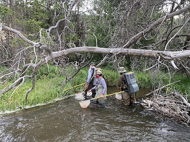
Kurt, Matt and Audrey working a nice deep hole.
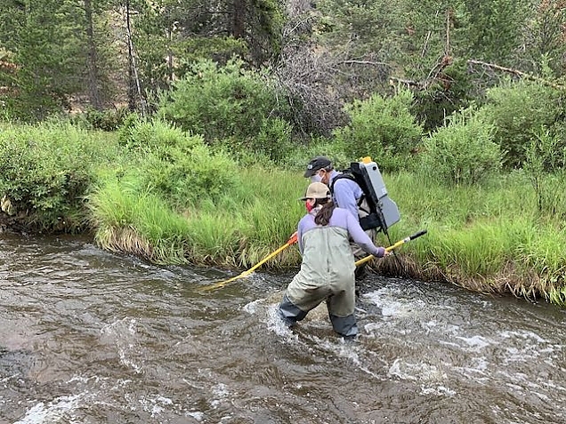
Kurt and Audrey in some fast water.
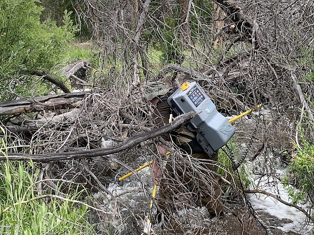
Matt was quite persistent in making sure we got every fish, even if it meant getting into a tangle of downed trees.
Audrey's goal was 40 brook trout from Sheep Creek. We got 41, along with a couple of nice brown trout (8" long or so), a sucker of some kind, and a fourth species that I don't recall. There is a lot of fish diversity in Sheep Creek. I've even caught a rainbow trout a few times.
In all, a long and tiring day, but very interesting and rewarding. I'm glad to say that as far as I know, we only lost one fish out of the roughly 200 caught. And, the results of the survey and genetic testing will help in the eventual restoration of native species to Colorado waters.
One final note. We observed COVID-19 safety protocols throughout the day by wearing masks. Yes, we were outdoors, but also in close proximity to each other. So, my only regret of the day is that I don't really know what any of those folks look like!


